
A Quick Snapshot of New York City
How big is New York City really? It covers about 469 square miles and holds over 8.4 million people.
That’s the short answer. Now let’s dig into what makes this city tick.
New York City is not just tall buildings and yellow cabs. It is rivers, bridges, parks, and millions of daily routines packed into five boroughs.
This snapshot gives you the numbers first. The rest of the article breaks down exactly what they mean and why they matter.
How Large Is New York City in Total Area?
New York City spans nearly 469 square miles, but here’s the twist. A big chunk of that is water, not land.
The city sits on islands and peninsulas, which is why boats and bridges matter so much here. It is one of the reasons NYC feels so different from sprawling cities like Houston or Los Angeles.
Understanding the land area versus water area split helps explain everything else. From traffic patterns to housing prices, geography shapes daily life in the city.
Total Geographic Area of New York City
So what is the exact total area breakdown? Land makes up 302.6 square miles, while water covers 166.3 square miles.
That water is not just decoration. The New York Harbor, Hudson River, and East River built this city’s entire economy.
Ships once lined these waters carrying goods from across the globe. Today those same waterways still shape shipping routes, ferry schedules, and even where people choose to live.
Distribution of Land and Water Across the City
Almost 35 percent of New York City is water. That is a massive number compared to most cities in the world.
This heavy water distribution creates hundreds of miles of waterfront neighborhoods. Places like Williamsburg and Battery Park City exist because of this coastal geography.
But water this close also brings risk. Coastal erosion, storm surges, and rising sea levels are real concerns city planners deal with every single year.
Natural Boundaries That Define New York City
What actually separates the boroughs from each other? Mostly rivers, and that’s not an exaggeration.
The Hudson River splits Manhattan from New Jersey. The East River runs between Manhattan, Brooklyn, and Queens like a liquid highway.
These natural boundaries turned New York into a trading powerhouse centuries ago. The same rivers that once carried merchant ships now carry ferries, kayaks, and tourists snapping photos of the skyline.
Elevation and Natural Landscape
Is New York City completely flat? Not even close, and Staten Island proves it.
Todt Hill on Staten Island rises to 401 feet, making it the highest natural point in the city. Manhattan has its own high spots too, like Washington Heights sitting around 265 feet up.
This elevation variation affects everything from drainage to how neighborhoods were built. Hilly areas developed differently than the flat stretches near the coast.
The Five Borough Structure of New York City
Why does NYC have five boroughs instead of one big city grid? Because each one grew with its own personality and purpose.
Manhattan handles finance and culture. Brooklyn holds the most people. Queens has the most land. The Bronx connects to the mainland. Staten Island stays quiet and green.
This borough structure is what makes New York function like five cities working as one team.
1. Manhattan: The Economic Core
Manhattan is tiny by land, just 22.8 square miles, yet it runs like the engine of the whole city.
Picture squeezing 1.63 million people into that small space. That gives Manhattan a jaw dropping density of about 72,000 residents per square mile.
Wall Street, Times Square, and Central Park all sit inside this one borough. It is proof that vertical construction can pack a lot of life into very little land.
2. Brooklyn: The Most Populous Borough
Brooklyn holds the crown for population, with roughly 2.6 million residents calling it home.
It stretches across 69.4 square miles, mixing old brownstone streets with brand new waterfront towers. Williamsburg and DUMBO show off this blend perfectly.
Redevelopment along the East River waterfront keeps pulling in new residents every year. Brooklyn keeps growing without losing its old school charm.
3. Queens: The Largest Borough by Land
Queens wins on space, covering 108.7 square miles, more than any other borough.
It is also famously diverse, with over 160 languages spoken across its neighborhoods. That makes Queens one of the most linguistically rich places anywhere on the planet.
Two major airports, JFK and LaGuardia, sit right inside Queens. That means this borough literally connects New York to the entire world.
4. The Bronx: Northern Gateway of NYC
The Bronx is the only borough physically attached to the U.S. mainland, no bridge required to reach the rest of America.
It covers 42.1 square miles and is home to Pelham Bay Park, a massive green space stretching over 2,700 acres. That’s bigger than Central Park by a wide margin.
Yankee Stadium and the Bronx Zoo also call this borough home. It blends sports, wildlife, and city life in one unique package.
5. Staten Island: The Least Dense Borough
Staten Island feels almost like a different world compared to Manhattan’s rush.
With about 495,000 residents spread across 58.5 square miles, its density sits far lower than anywhere else in the city. Suburban homes and quiet streets define much of the landscape here.
Todt Hill gives residents panoramic views of the harbor. It is the calm cousin in New York’s five borough family.
ALSO READ:Arch Aplin Architecture: Home Design and Key Dimensions
How Land Is Used Across New York City
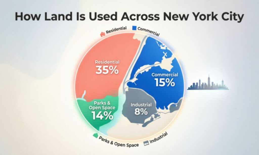
With limited space, every inch of New York City has to earn its keep. That means careful planning between homes, offices, and open land.
Land use here splits into a few clear buckets. Residential, commercial, industrial, and recreational space all compete for room.
Getting this balance right keeps the city functioning without collapsing under its own weight.
Residential Development Patterns
Housing 8.4 million people takes creativity, not just square footage.
You’ll find high-rise towers in Manhattan standing right next to historic brownstones in Brooklyn. Public housing developments and low-rise blocks fill out the outer boroughs too.
This mix of residential development styles reflects both history and necessity. Where land is scarce, buildings simply grow taller.
Major Commercial Districts
New York’s economy runs through a handful of powerful business zones.
Midtown Manhattan and Lower Manhattan handle much of the city’s finance and media work. Downtown Brooklyn and Long Island City have grown into serious commercial hubs too.
These commercial districts hold millions of square feet of office space. They are the beating heart behind New York’s global business reputation.
Industrial Waterfront Zones
Not every waterfront in New York is about pretty views and picnics.
The Brooklyn Navy Yard and Sunset Park’s industrial district still support manufacturing and shipping work. Red Hook’s port area keeps goods moving in and out of the city daily.
These industrial zones are getting a modern makeover too, blending old warehouses with new creative spaces. It is history and hustle sharing the same block.
Parks and Open Space Network
Even a concrete jungle needs room to breathe.
Central Park, Prospect Park, and Pelham Bay Park give residents space to walk, relax, and escape the noise. Flushing Meadows Corona Park adds even more green space to the mix.
This open space network improves air quality and gives city life some much needed balance. Without these parks, New York would feel a lot more claustrophobic.
Population Size and Urban Density
New York City holds around 8.46 million residents, making it the largest city in the entire United States.
But the real story is not just the number, it is how tightly people live together here. That crowding shapes housing, transit, and even how loud your neighborhood feels.
Density this high creates both energy and challenges, and New York has learned to manage both for over a century.
Current Population of New York City
The current NYC population sits close to 8.46 million people based on recent estimates.
That number swells during the workday though. Commuters, tourists, and workers push the daytime population toward nearly 10 million people.
Imagine an entire extra city showing up just for the workday. That is basically what happens in Manhattan every single morning.
Population Density Across the New York Boroughs
Not every borough feels equally packed, and the numbers prove it.
Manhattan tops the list at about 72,000 residents per square mile. Staten Island sits at the opposite end, with roughly 8,400 people per square mile.
This population density gap explains why Manhattan feels like a beehive while Staten Island feels more like a suburb. Same city, completely different pace.
Daily Population Surge from Commuters
Every weekday morning, New York basically doubles down on people.
Trains like the Long Island Rail Road and Metro-North Railroad flood Manhattan with commuters from the suburbs. New Jersey Transit and regional highways add even more traffic into the mix.
This daily surge stretches subways, sidewalks, and coffee lines to their limits. It is proof that New York never really sleeps, even before sunrise.
Historical Expansion of New York City
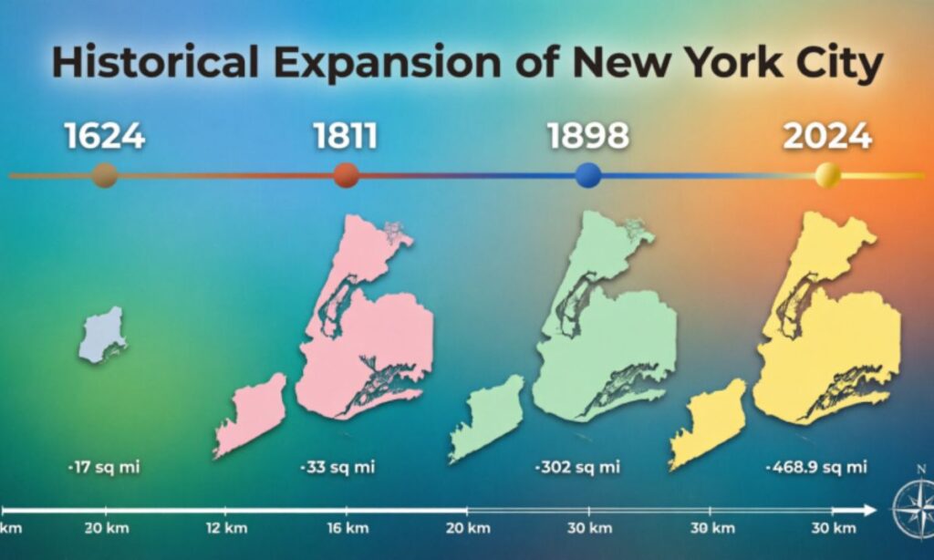
New York did not become a global metropolis overnight, it took centuries of migration and hustle.
From a small Dutch trading post to a sprawling five borough giant, the city’s growth mirrors bigger shifts in American history. Every wave of newcomers left a mark on its streets.
Understanding this historical expansion helps explain why the city looks and feels the way it does today.
Early Colonial Settlement
Dutch settlers founded New Amsterdam back in 1624, right near the southern tip of Manhattan.
The natural harbor attracted traders almost immediately. Small farms, wooden docks, and simple markets slowly built up along the shoreline.
Over time, that little trading post grew into the foundation for modern New York City. Not bad for a settlement that started with a handful of colonists.
Industrial-Era Population Boom
The 1800s changed everything for New York, turning it into America’s front door.
Millions of immigrants arrived through Ellis Island, chasing jobs and new beginnings. Factories, railroads, and shipping industries exploded almost overnight.
This industrial boom packed neighborhoods tight and built the working class backbone of the city. Many of today’s oldest buildings trace back to this exact era.
Post-War Urban Transformation
After World War II, city growth actually slowed down for a while.
Suburbs pulled families away from crowded neighborhoods, and New York had to adapt fast. But by the late 20th century, investment and immigration brought the city roaring back.
Neighborhoods like SoHo, Tribeca, and Williamsburg transformed from quiet or industrial areas into some of the trendiest spots in the city. That kind of comeback is very New York.
Modern Demographic Trends
New York keeps reinventing itself, even today.
New housing projects and transit access are pulling residents into outer borough neighborhoods that used to be overlooked. Young professionals, students, and skilled workers keep reshaping who lives where.
Experts expect the population to inch closer to 9 million within the next decade. If history is any guide, New York will keep finding room for more people.
Transportation Networks That Power New York City
How do 8 million people actually move around without total chaos? The subway does most of the heavy lifting.
New York’s transportation system is massive, complex, and somehow works most of the time. Trains, bridges, and sidewalks all play their part.
Without this network, the city simply could not function at its current scale.
NYC Subway Network
The subway is the real backbone of New York City life.
With 665 miles of track and 472 stations, it is one of the largest transit systems on the planet. Roughly 3.6 million people ride it every single day.
Run by the Metropolitan Transportation Authority, the subway operates 24 hours a day. Very few cities in the world can say their trains never stop running.
Major Bridges and Tunnels
Rivers may separate the boroughs, but bridges stitch them right back together.
The Brooklyn Bridge, Manhattan Bridge, and Williamsburg Bridge connect Manhattan to Brooklyn. The Verrazzano Narrows Bridge links Staten Island to the rest of the city.
These crossings carry millions of car trips, bike rides, and foot journeys every week. They are as iconic as the skyline itself.
Walking and Cycling in the City
Not everyone in New York relies on trains or cars, plenty of people just walk.
Short distances between neighborhoods make walking surprisingly practical here. Protected bike lanes and waterfront paths have made cycling a real option too.
This mix of pedestrian infrastructure helps ease subway crowding and cuts down on traffic. Sometimes the fastest way across town really is on foot.
Vertical Development and Skyscraper Growth
With almost no room to spread outward, New York had one option left, build up.
That decision shaped the entire skyline you see in movies and postcards today. Height became the city’s answer to a land shortage.
This vertical growth is not slowing down either, new supertall towers keep reaching higher every few years.
High-Rise Buildings Across NYC
New York now holds more than 6,000 high-rise buildings, most packed into Manhattan and Brooklyn.
These towers house offices, apartments, and hotels for millions of residents and visitors. Without them, there simply would not be enough room for everyone.
This vertical development pattern is part of what makes New York’s skyline so instantly recognizable worldwide.
Tallest Buildings in New York City
Some of the world’s most famous skyscrapers rise right here in New York.
One World Trade Center stands at 1,776 feet, a height chosen to honor the year of American independence. Central Park Tower and 111 West 57th Street aren’t far behind either.
These supertall skyscrapers keep pushing the boundaries of engineering and design. Each new tower adds another chapter to the city’s ever changing skyline.
Essential Infrastructure Behind the City
Beneath every busy sidewalk, there is a hidden world keeping New York running.
Pipes, tunnels, and cables snake underneath the streets, delivering water, power, and drainage to millions of homes. Most residents never think twice about it.
This essential infrastructure is what quietly makes daily life in New York possible.
Water Supply System
New York’s drinking water system is honestly kind of amazing.
The city relies on 19 reservoirs and 3 major water tunnels to move water into homes. Over 7,000 miles of water mains spread that supply across every borough.
Each day, this system delivers more than 1 billion gallons of clean drinking water. That is enough to fill thousands of swimming pools daily.
Sewer and Drainage Network of New York
Where does all that used water go afterward? Straight into a massive underground sewer network.
New York’s drainage system stretches over 7,400 miles, carrying wastewater and stormwater away from homes and streets. It is one of the oldest and largest systems of its kind.
Keeping this network running smoothly prevents flooding and keeps neighborhoods livable, especially during heavy storms.
Energy and Power Grid
Powering a city this size takes serious infrastructure.
Power plants, substations, and miles of underground cables distribute electricity across all five boroughs. Everything from subway trains to skyscraper elevators depends on this power grid.
Keeping the lights on for 8 million people is no small task, and this grid does it around the clock.
Green Spaces and Environmental Features
New York might be famous for concrete, but green space plays a bigger role than people expect.
Parks, trees, and community gardens are scattered across all five boroughs. These spaces offer a break from the density and noise.
Environmental planning is also becoming a bigger priority as the city faces new coastal challenges.
Major Parks and Recreation Areas
New York manages more than 30,000 acres of parkland citywide.
Central Park, Prospect Park, and Pelham Bay Park are just a few of the big names offering trails, lakes, and sports fields. These parks give city dwellers a real escape without ever leaving town.
This kind of green infrastructure keeps residents active and mentally recharged, which matters a lot in a fast paced city.
Urban Trees and Community Gardens
Look up on almost any New York street and you’ll probably spot a tree.
The city is home to over 5 million trees planted along sidewalks and inside parks. Community gardens also turn small vacant lots into neighborhood gathering spots.
These urban greening efforts improve air quality and give neighborhoods a bit more life and color.
Climate Resilience and Coastal Protection
Being surrounded by water comes with real risks, and New York takes them seriously.
Engineers work on flood barriers, elevated waterfront parks, and shoreline restoration projects. These efforts protect against rising sea levels and stronger storm surges.
This focus on climate resilience has grown a lot since Hurricane Sandy hit the region hard back in 2012.
Future Development and Urban Expansion

New York never really stops building, and the next decade looks just as busy.
Major projects are reshaping neighborhoods, transit hubs, and housing supply across the city. Growth here is constant, even after centuries of expansion.
These plans will decide what New York looks like for the next generation of residents.
Major Construction Projects
Some huge projects are currently reshaping the city’s skyline and neighborhoods.
Hudson Yards stands as the largest private real estate project in U.S. history. The Penn Station redevelopment and Brooklyn waterfront revitalization projects are also picking up steam.
These construction projects represent the next big wave of New York’s ongoing transformation.
Housing Growth Strategies of New York
With population numbers climbing, housing has become a top priority for city planners.
Affordable housing construction, mixed use developments, and transit oriented communities are all part of the plan. The goal is simple, keep the city livable while it keeps growing.
These housing strategies try to balance growth with everyday affordability, which is easier said than done in a city this expensive.
Fun Facts About New York City
New York has a few surprises that even locals sometimes forget about.
Staten Island is home to the Snug Harbor Cultural Center and Botanical Garden, complete with a small zoo tucked inside. Not exactly what people picture when they think of Staten Island.
The Brooklyn Bridge was the first steel wire suspension bridge ever built, way back in 1883. Over 4 million people still walk across it every single year.
Central Park spans 843 acres, technically making it larger than the entire country of Monaco. And despite feeling completely natural, the whole park was actually man made from scratch.
Test Your New York Knowledge
Think you know New York City well? Let’s put that to the test with two quick challenges.
Challenge 1: Guess the Borough!
Match each landmark to its correct borough.
● Yankee Stadium
● Coney Island
● Flushing Meadows Corona Park
● Staten Island Greenbelt
● Times Square
Hint: every answer already appeared earlier in this article, so no cheating.
Challenge 2: True or False?
Test your trivia with these four statements.
1. Manhattan is the largest borough by land area.
2. NYC has over 500 miles of shoreline.
3. The subway system is completely underground.
4. Staten Island has the highest natural elevation in the city.
Answers:
5. False, Queens actually holds that title.
6. True, the shoreline stretches roughly 520 miles.
7. False, plenty of subway track runs above ground in the outer boroughs.
8. True, Todt Hill sits 401 feet above sea level.
Conclusion
New York City packs an incredible amount of life into a relatively small footprint. From its five boroughs to its underground water tunnels, every piece works together to keep millions of people moving each day.
Whether you are drawn to the skyline, the parks, or the sheer energy of the streets, New York rewards a closer look. The more you learn about its size, history, and structure, the more impressive this city becomes.
So next time someone asks how big New York really is, you’ll have way more than just a number to share.